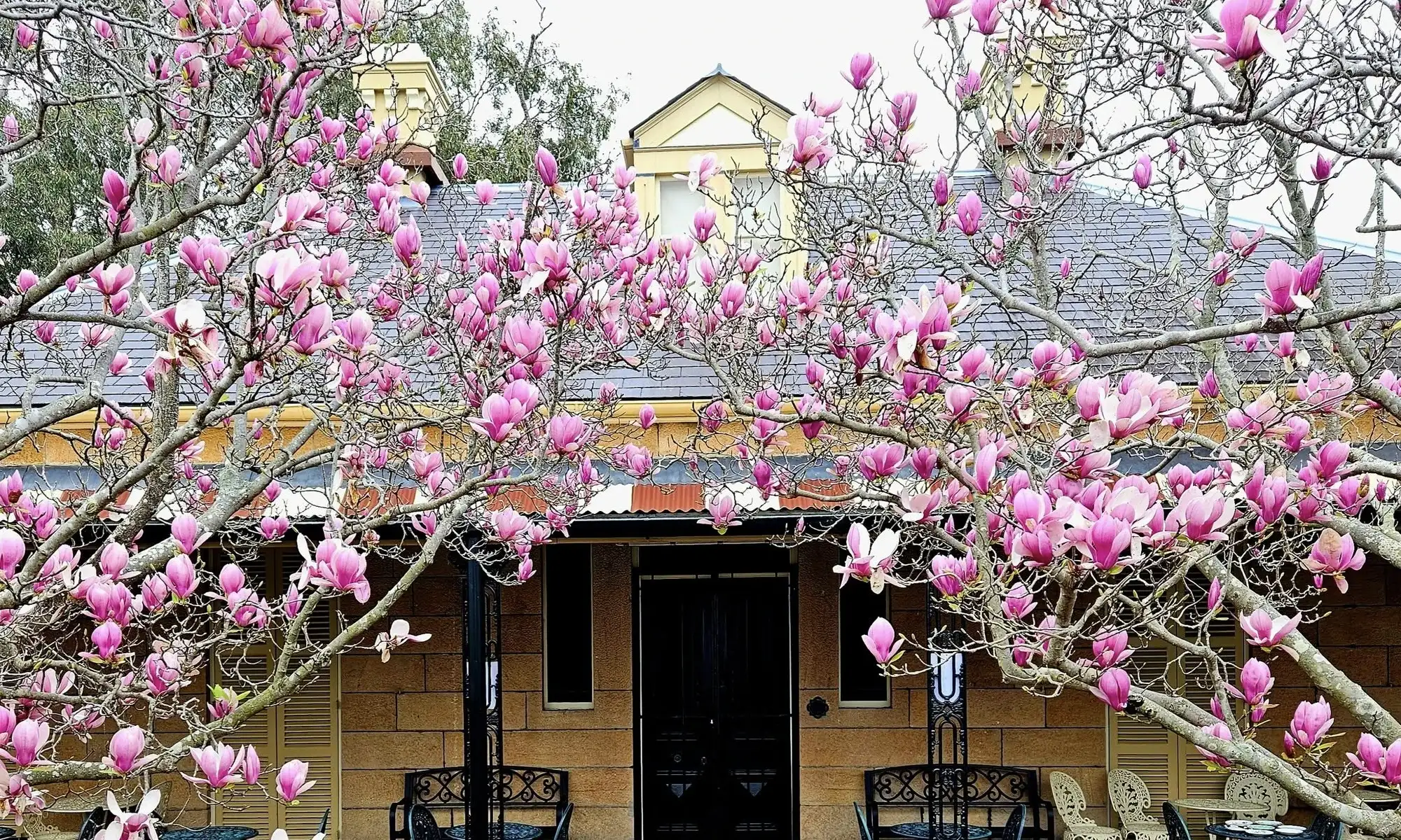

For the first time in decades, Lydham Hall Historic House Museum has a new outbuilding.
The original residents in the late 1800s and early 20th century had use of a set of sandstone buildings: a kitchen, stables, and servants’ quarters.
The arrival of the railway and tramway accelerated the pace of development in the surrounding area, shrinking the original estate to its current dimensions. As it was steadily subdivided for new housing, the outbuildings were demolished.
The sandstone was reused in 1916 to extend the southern edge of Lydham Hall. The verandah on this side of the home was removed to allow for two kitchens – 1 modern version used by our volunteers during Open Days and events, and a second room comparable to an early 1900s kitchen.
As horses are unlikely to trot onto the estate, and there are no live-in servants, the other outbuildings were not replaced.
In 2025, we were awarded a grant from the Bendigo Bank Community Enterprise Foundation to purchase a storage shed. 2 of our SGHS volunteers, Reg and Ray, assembled the new outbuilding, discreetly placed behind the hedge along the southern fence. We can now easily access furniture and other equipment used for our events. These items were previously stored in the house. Since this change, our visitors can enjoy the access our exhibition room and additional items in our collection, previously hidden from view.
Thanks to our local Bendigo Bank branch on Forest Road, Bexley, and to Reg and Ray for this new shed.
Portrait of Governor Macquarie, most likely by John Opie, 1805 (courtesy of Mitchell Library, State Library of New South Wales)
Lachlan Macquarie arrived in Sydney on 31 December 1809 to succeed William Bligh as Governor, after the Rum Rebellion. During the next 12 years, he made a number of extensive tours through NSW and Van Diemen’s Land (renamed Tasmania in 1856). He kept a journal during his tours, and in 1956, it was published by the trustees of the Public Library of NSW (renamed “State Library of New South Wales: in 1975). The original is held in the Mitchell Library.
His first tour commenced on Tuesday, 6 November 1810, and, during the next five weeks, Macquarie visited and named Liverpool, Windsor, Richmond, Castlereagh, Pitt Town, and Wilberforce. Using Parramatta as his main base and covering up to 65 kilometres in a day, he inspected farms in the area bounded by Menangle, Baulkham Hills, and the Nepean at the foot of the Blue Mountains. This covered the full extent of settlement at the time.
On the last day of this first tour, Thursday, 13 December 1810, he set out from Parramatta to visit the farms to the south of the Parramatta Road, before returning to Sydney. On this day’s journey, he visited Kogarah Bay, Kingsgrove and Canterbury, by way of what is now Campsie, Kingsgrove and Hurstville, and returning the same way.
Macquarie travelled with ceremony and state. On this tour, in addition to the carriage conveying the Governor and his wife, Elizabeth, there were his staff (usually five or six), and sometimes there is mention of servants with two carts for tents, food and other gear. One day there is mention of four troopers. There is no reference to troopers on the day of his visit to this district, but they may have been present. There would certainly be the servants to prepare the ‘breakfast (which we had carried along with us)’ and presumably a cart to carry it.
The most interesting point to be gained from Macquarie’s entry in his journal is that there was a track through the ‘thick forest’ which was good enough for a carriage and a cart to use. The track ran from Parramatta Road, Homebush, to Kogarah Bay, by way of Campsie, Kingsgrove, and Hurstville, and this was only six years after Hannah Laycock was given her grant at Kingsgrove, and two years after the Townson brothers were given their initial grants in the area between Bexley and Peakhurst. The track was sufficiently good for the journey (21 km as the crow flies) to take only two hours from Homebush to Kogarah.
Macquarie’s portable writing desk, c. 1805 (courtesy of Museum of Sydney Collection, Museums of History New South Wales)
The entry for Thursday, 13 December 1810, in Macquarie’s journal is quoted in full. Some notes follow:
“Thursday 13th. Decr. 1810. —
The Farms lying on the shores of Botany Bay, on Cook’s River and in the small District of Petersham, between Sydney and Botany Bay, being the only ones in the Colony now remaining unexplored in my present Tour of Inspection, I set out this morning at 7 O’Clock from Parramatta with Mrs. Macquarie in the Carriage, and accompanied by the Gentlemen of our Family and the Surveyor, to visit those Farms on my return home to Sydney. — We struck off at Powell’s Half-Way-House1 through the Woods, and after a very pleasant Drive through a thick Forest, arrived at Capt. Townson’s Farm House on Botany Bay2, at half past 9,O’Clock. We found the Captain at home in his very pretty neat clean little Cottage, where he received us with hospitality and in a Gentlemanlike manner; and whilst our Breakfast (which we had carried along with us) was getting ready, he walked with us to shew us his Garden, and all the other little improvements of his Farm. — His Garden we found in excellent order, and producing the largest and best Strawberries I have yet seen or eat [sic] in this Colony. — After Breakfast we embarked on the Water in Capt. Townson’s Boat, in order to see his own and his Brother Doctor Townson’s Farm3, which join each other at this Place. — The Doctor’s Farm we found in miserable bad order, with only one Solitary Hut on it, occupied by two of his indented Servants, a man and his wife – the latter being very sickly and to all appearance half starved; there were no appearance whatever of any improvements on this Farm, which is as yet in a state of nature.
Having viewed these Farms, we proceeded for five or six miles down Botany Bay until we opened the Heads and Entrance of it, and then returned to Capt. Townson’s Cottage after a two hours very pleasant Water Excursion. — At 1. P.M. We set out again from Capt. Townson’s for Mrs. Laycock’s Farm near Cook’s River4, and arrived there at half past 2,O’Clock. — We found Mrs. Laycock and her two Daughters at home, in a very neat comfortable well built Farm House and well furnished; the good old Lady’s Farm being also in a forward state of improvement in other respects. — After resting for half an hour at Mrs. Laycock’s, we pursued our Journey on to Canterbury; thus crossing Cook’s River5 twice over a very slender bad Bridge within two miles of Mrs. Laycock’s Farm, and is rather dangerous for a Carriage. — At 4. P.M. we arrived at Canterbury6, a Farm belonging to Mr. Robt. Campbell Senr. Mercht. at Sydney. — It is an extensive Farm, and a good deal of the wood has been cleared,;but the Soil is bad, and neither good for Tillage or Pasturage.
Hannah and Thomas Laycock
I quitted the Carriage and mounted my Horse at Canterbury in order to inspect the few remaining small Farms between this and Sydney; Mrs. Macquarie proceeding in the Carriage by the Main Road, to meet and wait for me at Grose Farm. — I called at Mr. Moore’s, Mr. Blaxcell’s, Mr. Blaxland’s, Capt. Rowley’s and several other smaller Farms in the District of Petersham7, all of which are poor and of little value; the Farm Houses, however, are tolerably good; and considerable pains have been taken to clear, enclose and improve the Lands.— At half past 5. P.M. I joined Mrs. Macquarie, whom I found in the Carriage near Grose Farm8, and there getting in to the Carriage again, we drove in to Sydney, arriving at the Government House at Six O’Clock in the Evening, having been absent on this very pleasant Tour of Inspection 5 weeks & 2 Days.”
This article was first published in the March 1982 edition of our magazine.
Unless noted, images courtesy of the Bayside Library Service Local History Collection.
This was at Homebush, near the present railway station ↩︎
Captain John Townson’s house was called the Retreat on Kogarah Bay, north of Carss Park. It took half an hour from Parramatta to Homebush, so it took two hours from Homebush to Kogarah with a carriage and a cart through thick forest – so the track must have been in reasonable condition. ↩︎
In actual fact, they didn’t adjoin, being separated by the present Carss Park. Dr Robert Townson’s grant of 75 acres comprised the whole of Tom Uglys Point. ↩︎
Hannah Laycock’s 500 acres extended from Stoney Creek Road to William Street, between Kingsgrove Road and Bexley Road. I believe that her cottage was situated near the present corner of Homer Street and Rosemeath Avenue. ↩︎
The crossing was probably at the northern end of the present Beamish Street. Beamish Street was the road leading to Laycock’s and Townson’s. ↩︎
Canterbury Vale was originally granted to Reverent Richard Johnson in 1793. ↩︎
This refers to a much larger district than the present suburb of Petersham. ↩︎
Grose Farm became the site of the University of Sydney. ↩︎
George Preddey was born in Bath, England in 1807. He arrived in Sydney aboard the convict transport “Prince Regent” on 27 September 1827, having been sentenced to seven years transportation at the Shrewsbury Assizes on 25 March 1826 for housebreaking (in Britain, Assize courts were replaced by Crown and Magistrates’ courts in 1971).
He was, by trade, a tallow chandler (made and sold candles of tallow (animal fat)), and on his arrival in Sydney, was indentured to Daniel Smallwood, a farmer of Pitt Town near Windsor (on the Hawkesbury River, 95 km northwest of Sydney).
Having completed his sentence, Preddey became first a mineral surveyor, then a dairyman and later a dray proprietor operating from premises in Castlereagh Street. By 1851 he was a corn chandler (seller) and sail maker. Finally he extended his interests to that of a timber merchant, and with two partners acquired the business of John Booth and Co., of Kent Street in addition to owning the Summerhill sawmill on the North Coast. During 1840 and 1841 he bought land at Macdonald River, Mulgoa, Ulladulla, and Mudgee.
His interest in timber no doubt influenced his decision to buy two parcels of land at Bexley in 1850 comprising 65 acres which today would be bounded by Forest Road, Stoney Creek Road, and Preddys Road – it is hard to believe that at that time that whole area was heavily timbered. Annie Stobie Preddey, wife of George Preddey Jnr, made available in 1907 to Bexley Council part of the Preddey Estate for £1,000, the land on which Bexley Park is now situated.
In April 1836, George Preddey married Margaret Carey at St. Phillip’s Church, Sydney, considered “the ugliest church in Christendom”. Margaret had migrated to Australia as a free settler some 18 months before. There were 13 children of the marriage, 4 dying in infancy. There is a stained glass window in Christ Church, Dunmore Street North, Bexley, given by George Preddey, the eldest son, and other windows in the church commemorate other members of the family.
Cricket match on Preddey’s back paddock, c. 1905, now Bexley Park
In 1860, he erected on the smaller of the two sites he had purchased a commodious two-storey residence which he named “Besborough” and he lived there in considerable comfort and style until the death of his wife in October 1876.
“Besborough”
Cattle on Preddey’s back paddock, c. 1900
George Preddey Jnr
The property was completely self-supporting with cattle and poultry, extensive vegetable gardens and a fine orchard. Preddey took two of his sons, George Jnr and William, into partnership in his business and acquired the business of John Booth and Co., Wholesale Fuel, Timber and Produce Merchants, which at one time was one of the largest suppliers of timber and cornmeal in the colony.
Preddey had not only become a man of wealth and considerable enterprise but a man of great religious faith. He was one of the first churchwardens of St George’s Hurstville Anglican Church – a church he was later to richly endow and in which there is a stained glass window in memory of him. He was Chairman of the Gannon’s Forest Road Trust which had responsibility for keeping the Illawarra Road in repair. He was also a member of the Board of the first government school built at Hurstville.
Annie Henderson Preddey
In April 1872, he added to his holdings at Bexley by purchasing the triangular piece of land adjoining “Besborough” which extended to the junction of today’s Stoney Creek and Forest Roads.
He is buried in the family grave at Woronora.
It is interesting to note the various streets in Bexley which have been named after members of the family, namely, Preddeys Road; Henderson Road is named after Anne Stobey Henderson who married George Jnr; and Besborough Avenue is from “Besborough”, the family home; Halley Avenue refers to another member of the family through marriage; Alice, one of George’s daughters, married Edward Milsop, hence Milsop Street, Carlton
Jean and George Preddey, 1932
Lewis, the eighth child, married a Miss Hannam, no doubt related to David Hannam of Arncliffe. Hector Wearne, first Town Clerk of Bexley, married Minnie, George’s fourth child. Walter Preddey, a grandson of George, married Emily Sussanah Kinsela, thus uniting two prominent Bexley families. Annie Henderson Preddey, another granddaughter, was a well-known Bexley identity.
Jean Preddey, a fourth generation descendant, most recently lived on the Preddey Estate, her daughter, Gloria Williamson and two children remind us that the pioneers of Bexley are very relevant to our present day.
This article was first published in the March 1982 edition of our magazine.
A sparsely settled area with much bushland frequently runs a risk of fire in summer time, so in September 1900 (the year of Bexley’s birth as a separate Municipality), the provisions of the Fire Brigades Act (1884) were extended to Bexley. Three years later (10 August 1903), Rockdale Council’s Alderman William Taylor, a Suburban Councils’ representative on the Fire Brigades Board from 1894 – 1922, addressed Bexley Council, advising that the Board hoped soon to place a sum on its estimates for the purchase of a site for a Bexley Fire Station. As a result, land at the southeast corner of Queen Victoria Street and Forest Road, with frontages to those streets of approximately 49 m and 65 m respectively, was acquired the following year. This land immediately became non-rateable and had to be struck off the Council’s Rate Book, with a consequent loss in rates, at that time of 17 shillings per annum.
As a fire station was urgently needed in the district, the Board decided to lease a property in what was later to become the Bexley shopping centre, for use as a temporary fire station. This was situated opposite the Post Office. The horse-drawn fire fighting appliance with which the station started in June 1905, may have been primitive, because a year later it is recorded that “an improved fire waggon was now available at the Fire Station”.
Metropolitan Fire Brigade and Fire Brigades Board in Headquarters Yard, c. 1898. William Taylor seated in centre with arms folded (courtesy of the Museum of Fire Collection)
The Board had, in July 1907, £1500 allocated to the construction of the future fire station. Unfortunately it took three years to select a tender and complete the work. In the meantime, the Fire Brigades Board submitted the name of Ernest Lindsay Thompson (architect, and City of Sydney alderman from 1900 – 1927) for insertion in the Municipal Roll for election purposes. The Council Clerk replied that the land was Government property, it was exempt from taxation and no Council vote could be allowed for it. The Board was charged by the Council for kerbing and guttering at the ordinary rates ruling at the time (1 shilling and threepence of total cost, plus 1 shilling each for pipeholes).
The single-storey brick station in the Federation Arts and Crafts style opened on 7 March 1910 with a fire bell used to summon any of a volunteer force who might be within hearing. On 14 April 1914, the Council resolved to ask the Fire Brigades Board for a permanent firemen. However, the First World War intervened and it was not until the following year that the request was acceded to.
In 1914, the first two telephone fire alarms went into service – at the corners of Union Street/Grantham Street and Webbers Road (now Willison Road)/Durham Street. A third alarm was installed at the Forest Road/Waratah Street corner in November 1921. Several others were installed in August 1939. Bexley Fire Station was connected to the Kogarah telephone exchange in March 1919.
In 1939, Bexley Fire Brigade was praised for its work at a fire in Bexley North.
However, a most unfortunate delay occurred in connection with a fire in a house at the corner of Shirley Street and Rawson Avenue in September 1944. Smoke was seen issuing from the windows at 4 pm and a passerby rang the Fire Brigade on the nearest public alarm. Waiting until 4.15 pm without result, he rang again, still without result, and finally went to the Fire Station in his own car. He was informed that the phone was out of order. Also, the person in charge of the station was a new hand and did not know where Rawson Avenue was located. The brigade finally arrived at the scene of the fire at about 6 pm. The extent of the damage is not known.
Photo of the former Bexley Fire Station in 1990, before a fence and trees hid the tall doors
The Council was anxious to have the district fire headquarters established at the Bexley Fire Station and in March 1926, made the request to the Board of Fire Commissioners, but it was refused. A request was also made in 1929 for some of the vacant corner of the fire station land, so that corner of Queen Victoria Street could be rounded, but this, also, was not agreed to. Fortunately, the fire station is set back 3 m from the “building line” at the corner and the rounding was still found to be possible.
Advertisement for the Dennis Big-4 (courtesy of the Museum of Fire Collection)
Willoughby Council initiated a move in 1936 to have Council contributions to the cost of fire brigades abolished and Bexley Council heartily cooperated, again without success. Bexley was paying a levy of about £750 at the time, but this had doubled by the time the Council ceased to exist.
What would now be regarded as primitive manual equipment was displaced in 1924 by the installation of a motor pumping engine. This was first promised two years earlier and when it finally arrived the Council, at its regular meeting on 29 July 1924 “left it in the Mayor’s hands to arrange a suitable function”.
In June 1935, a modern Dennis “Big 4” engine (manufactured by Dennis Brothers Limited in Guildford, England) was installed, but apparently without ceremony.
Dennis Big-4 Fire Engine, c. 1970 (courtesy of the Museum of Fire Collection)
The need for a new Council Chamber had become evident just before the second World War. Various sites were suggested and West Kogarah Progress Association urged Council to buyback land which appeared to be surplus to fire station needs. Nothing came of the idea.
The Fire Brigade had been ably served by its volunteers in the early days, so in 1932, the Board of Fire Commissioners was pleased to present long service medals to mark its appreciation. On the other hand, the Fire Brigade Employees Union was seeking a reduction in working hours for firemen from 84 to 56 per week.
It had been proposed in 1930, that Bexley Fire Station should be closed. The Council suggested that if this took place it should be used to house a family or two, or alternatively, be used as a Boys’ Club.
The onset of the war caused the retention of the station as a “second line of defence”, with two fully-equipped fire engines of large pumping capacity, housing accommodation for one officer of the brigade and a large building alongside for a number of “lend-lease” fire engines.
After the war, the building became a Brigade workshop.
Finally, Bexley Council, nearing the end of the Municipality as a separate entity, was told by the Board that adequate fire protection could now be provided by existing fire stations In the adjoining suburbs of Rockdale, Kogarah and Hurstville, so in 1945, Bexley Fire Station, like its counterpart at Arncliffe, was closed. The interior was later converted to accommodate residential apartments.
Muddy Creek is now no longer a muddy creek, but a large stormwater channel carrying almost all the drainage from the higher lands of parts of Hurstville, Carlton, West Kogarah, and Rockdale. Nobody seems to know just where it starts from, as there are so many drains and street gutters flowing into it.
It comes under the railway line about midway between Rockdale and Kogarah. The first thing we notice from this point is a lovely line of willow trees on the right which help to cover up an unpleasant sanitary tip. On the left we see an old cottage owned firstly by the Skidmores, one of the pioneer families of this district, now occupied by Frederick’s granddaughters. From there on to Princes Highway it is built on with homes and factories and is not seen by passing people. Past Princes Highway on the right used to be Reuters vegetable garden and orchard, On the left was a paddock, then came now wholly taken up by the Shopping Plaza. the late John Proctor Lister’s very fine property, on the right was Mascord’s garden, now the Air Force base, and their bowling green. On the left again was Gearson’s Garden, then James Beehag’s land, now the lllawarra Tennis Courts. From there to Bay Street it is all built on, but the right hand side is still mostly vacant land.
From Bay Street to the crossing at West Botany Street, the whole of the left side is taken up with the Youth Centre, and on a Saturday afternoon, is quite a gay sight with hundreds of children playing all kinds of sport. On the right hand side is the Rockdale Bowling Club, with its four greens and large clubhouse.
Crossing West Botany Street on the right was one of the first market gardens in this district, owned by the late Charles Napper. He was one of the first six aldermen to form what is now the Rockdale Council. He was also a leader in many other progressive moves for the welfare of Rockdale. His old garden has made way for the new Elizabethan Ladies’ Bowling Club, which is a gay sight now at weekends.
Muddy Creek, c. 1945
On the left are the Chinese market gardens, originally owned by David Wilson. Following on south eastern, is the garden originally owned by John Bowmer, who was a well known pioneer of this district. Bowmer was Mayor of Rockdale for seven years. He also was the Returning Officer for State Elections, member of the school board and held many other honorary positions. His old garden is still in the Bowmer family, being worked by a grandson. From here on to Bestic Street is mostly vacant land on both sides.
1957 sign
On the right hand side past Bestic Street is the Fishermen’s Club, with a nice halt and many boats of various kinds anchored in the water, making a very pretty sight.
Muddy Creek, 1968
On the left is Barton Park, which is a large playing area under the control of Rockdale Council.
From here, Muddy Creek enters what is generally known as the Canal, being an arm of Cooks River, and finally into Botany Bay.
This article was first published in the August 1966 edition of our magazine.