An extract from Rising Damp: Sydney 1870-90 by Shirley Fitzgerald
To the south of the city, the Illawarra line, opened in 1884, generated a second set of new suburbs. Marrickville, south of Petersham did not lie on the railway line, but benefited from its position between the two lines. Its population, which rose from 3500 in 1881 to 13,500 in 1891 participated in the suburban boom both as consumers of new housing and makers of bricks. By 1890 some mechanised kilns were in operation, but had you gone there on one of the trams which had serviced this suburb from 1881, you would still have seen many brickmakers making bricks by hand in the time-honoured fashion.
Beyond this, in Rockdale, Hurstville and Kogarah, lived 10,000 people in 1891. Back in 1870, the Sands Sydney and Suburban Directory did not recognise the region as being suburban to Sydney, and as late as 1881 Kogarah was still recorded in its Country Directory. Before the coming of the railway, land communications were not always assured, as the crossing of the Cook’s River sometimes became difficult and the river flats around Canterbury and Marrickville could quickly turn to quagmire. An old dam at Tempe helped to prevent tidal flushing of the river and increased flooding problems upstream, while the clearing and settling of the land, especially in Marrickville, encouraged runoff. Most residential development was around the railway stations, and by far the most common form of construction was the small detached cottage, although there were some elegant houses and a few mansions in the elevated part of Hurstville, which was coming to be known as Bexley.
Many of the cottages were built of timber, although brick became more usual as settlement spread, and following the establishment of the Hurstville Steam Brick Company in 1884. The old wooden St George’s Church at Hurstville was replaced by brick in 1889, after a white ant problem had caused the disappearance of the clergyman through the floor of the pulpit, so the folklore goes, immediately after delivering a sermon on the text “Let him that thinketh he standeth take heed lest he fall”. Many investors and would-be land developers in this area were often uncertain as to whether their fortunes would rise or fall.
The railway had brought suburbs to Kogarah and Hurstville, but much of the intensification of land use in the area was for rural-urban purposes- orchards, poultry farms and the like. Development was not nearly as extensive as on the western line, and land prices did not go so high. Partly this was a result of timing, because although the opening of the Illawarra line in 1884 coincided with the height of the suburban boom, it had run its course within a few more years.
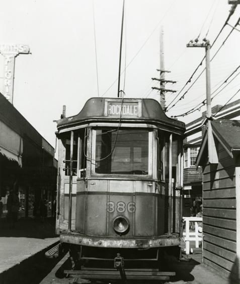
Partly though, the slower growth of this area was the result of an ambivalent relationship between this region and industrial Botany, to the north. Nowhere was this more evident than in West Botany. Some residents possessed a vision of the area as a major seaside resort, like Thomas Saywell, who constructed a private tramway at a cost of 15,000 pounds from Rockdale Station to Lady Robinson’s Beach, where seabaths, picnic grounds, an onion-domed pavilion and a grand 60-room hotel named “New Brighton” were all subsequently built although surrounding roads were unmade and houses few in number.
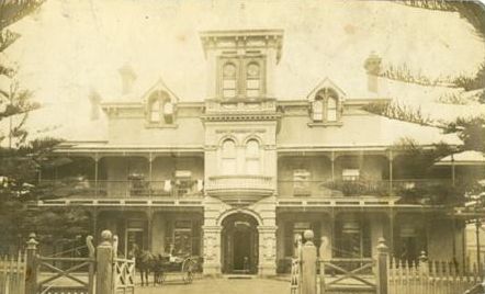
Other speculators persuaded the government to build a tramway to Sans Souci in 1887, and in that year the municipality changed its name to Rockdale, no doubt because it was felt that a would-be resort, or even an ordinary suburb could only be hindered by a name like West Botany, so firmly associated with industrial development.
On the other hand, some residents did want to develop Rockdale as an extension of Botany, and by 1890 there was a limited amount of noxious activity, especially around Arncliffe, on the Cook’s River estuary in the vicinity of Wolli Creek. Nearby on the spit of land jutting out from the head of Lady Robinson’s Beach into the river was the government sewage farm, which began taking the outfall of the southern sewerage line in 1889. The location of these activities in the north of Rockdale around the extensive mud flats and mangrove swamps at the mouth of the Cook’s River was crucial in discouraging Sydney’s residents from using the land beyond, either for residential or recreational purposes. Predictably, local council elections were often fought over the question of noxious trades, with the security of the local manufacturers waxing and waning with the changing factions in power.”
“The story of municipal government is a major study in itself, and varies from place to place, but from the newspapers and parliamentary reports of the period 1870-90, it is very difficult to concede that local government was for the good of the citizens of Sydney, and difficult to avoid concluding that the initial enthusiasm for forming municipalities was motivated by a desire to ensure that the incorporated areas were left to their own devices and developed in ways that most benefited the landholders, subdividers and manufacturers. The incorporation of Kogarah is a good case in point.
Kogarah was incorporated in 1886, after two years of protracted negotiations over the issue of whether it should be incorporated at all, and where the boundaries should be. There was no upsurge of civic pride in a well-defined area, but much toing and froing over which area would produce the greatest benefit to the interested parties. Incorporation was at the ‘will and initiation’ of the citizens, and the mechanics of becoming a municipality involved raising enough local interest, usually via public meetings, to put together a petition to the colonial government, which then considered the merits of the case, and normally granted incorporation if there was a strong local demand for it. Local interest was very freely defined, however. The population of semi-rural Kogarah in 1884 consisted of a few fishermen, a lot of market gardeners, several poultry farmers and nursery men and a number of tradesmen – stonemasons and a few labourers possibly associated with the small brickworks of Young and Cross on Hurstville Rd. There was also an Aboriginal settlement in Vista Street, off Rocky Point Road. Of the forty people who gathered at the Gardeners’ Arms, Montgomery Street, on Monday, 7th April 1884 to discuss a number of local issues, almost certainly none were women or Aborigines, and probably very few were gardeners, labourers or fishermen. People who spoke at this and subsequent meetings, however, included James Todd and John Whitehead of the city, and H.G. Swymy, of Randwick, all owners of freehold land in Kogarah.
This meeting was not specifically about incorporation, but at the end of it a committee was formed to “watch local matters and to take steps to ensure the progress of the district”. Motions were passed in favour of excluding noxious trades from the area, in protest over the disgraceful state of the main roads from the Cook’s River to George’s River and for a railway in the same area. The first issue, that of the noxious trades, was in response to the rumours that the Stuart government was possibly considering the George’s River area as a noxious trade site, while the interest in roads and the railway was summed up by Joseph Carruthers, one of the prime movers for incorporation, who observed at one meeting that, “they all knew that if they wished to induce people to build there they would require to show them roads and other conveniences of civilisation. They should not wait until there were two or three hundred houses in the district before taking any steps for the formation of a municipality.”
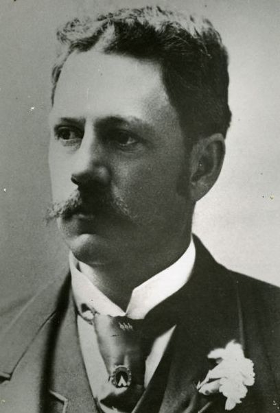
The motive for encouraging the rail to go all the way to the George’s River was to prod the government into keeping to schedule with the line, for there was widespread feeling that it had been too much delayed. When it was finally opened as far as Hurstville on 15 October, the Herald described the area as ‘a beautiful resort’, an ‘arcadia’, which would be of enormous benefit to the people of Sydney as a recreational area. Some men, however hoped that the railway would bring about the rapid metamorphosis of arcadia into suburbia. The first petition in favour of incorporation was followed by one against, and one meeting for an incorporated Kogarah was followed, within a fortnight, by another at Hurstville proposing a joint municipality with that area. Landholders (presumably with land in Kogarah), fearing that rates would be dissipated over the larger area, argued that small municipalities were always the most flourishing. Finally, when a petition for Kogarah, without Hurstville, was gazetted in July 1885, a dispute broke out over part of the boundary with West Botany (Rockdale) and after incorporation was finally granted, complicated and not very friendly negotiations continued with this municipality. for several years over boundaries. Clearly, suburbs were being made, not through the growth of ‘community’, but by individuals like Joseph Carruthers, who were angling for the deal most likely to benefit their own financial and landed interests. He was a young solicitor who ‘made investment in land a sideline’, and a few years later, in 1887, he went into parliament at the top of the poll for the seat of Canterbury. In his maiden speech he called for a tramway from Kogarah to Sans Souci, where he lived. In 1889, when he became Minister for Public Instruction, he immediately took steps to have a larger school built at Kogarah. Later, when he became Premier of New South Wales, he continued to be closely associated with the district – ‘he had a lot of sway, and could get anyone a job’, as one local resident recalled.
Carruthers worked for Kogarah and Kogarah worked for Carruthers. This story of incorporation could be repeated over and over for other districts and would-be districts of Sydney.”
This extract was from Rising Damp: Sydney 1870-90 by Shirley Fitzgerald, Oxford University Press, 1987. Purchase at AbeBooks.
(Images courtesy of Bayside Library Service Local History Collection)
