by Arthur Ellis
I deem it a privilege to address you on this occasion on a history of Carss Park, a residential and recreational precinct 17 km from Sydney off the Princes Highway and extending to Kogarah Bay.
Perhaps the story starts in the year 1800 when James Carss and his wife Mary Nelson produced a son whom they called William. I have not established exactly where William was born but it was probably in or near the town of Dunse (spelt more recently on modern maps Duns) in the Scottish county of Berwickshire. Duns is about 21 km west of Berwick on the Northumberland North Sea coast.
He was trained as a cabinetmaker and examples of his immaculate work survive at known locations.
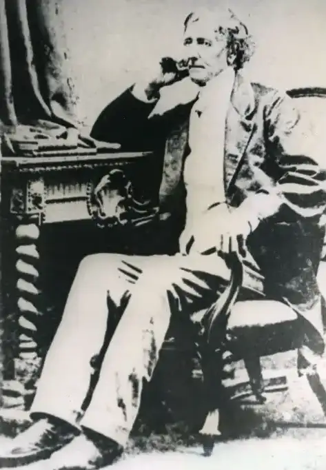
At age 31 years William Carss migrated to New South Wales as part of a scheme organised by the Rev. John Dunmore Lang, a leading Scottish Presbyterian clergyman who needs no introduction to those who have looked at nineteenth century Sydney life.
Accompanying him to the Colony was his wife, Helen Turnbull, who like many Scottish women of the time retained her family name, albeit at times as a “middle” name. She bore five children, three of whom survived infancy named Mary, Anne and James.
Also with William and Helen Carss were several Scottish mechanics, clergy and teachers. One writer suggests that the influx of Scottish Presbyterian mechanics had the effect of markedly raising the standards of building in Sydney and also bring about a moral improvement in the city of Sydney including “diminished drunkenness”. Maybe because there were more wowsers about.
At this distance in time we cannot be certain what became of the relationship between the Rev. Lang and William Carss as within less than ten years Carss was a well known keeper of pubs.
It was during his control of the Clarence River Inn in Sussex St. Sydney that his wife Helen died aged 47 years (The Empire newspaper 27th June, 1853 p.2438). She was buried at the Sydney Burial Ground called the Sandhills, and her grave and that of the two infants who died, with monument was still there when recorded by Mr. and Mrs. A.G. Forster in 1901, when the clearing of the Sydney Burial Ground was imminent, to make way for the construction of Sydney Railway Station. See Sainty & Johnson Gravestone Inscriptions, Genealogical Publication of Australia 1973, Introduction pp.iv-v, and page 128 Item 2270 and Register of Graves at Bunnerong Cemetery kept at that place and consulted by this writer, October 1987.
Does this clear up the confusion raised concerning the legend of William Carss exhuming his wife’s remains in the Western Suburbs and re-interring them at Carss Park?
About the time of Helen’s passing there was advertised in the New South Wales Government Gazette, on Friday 22nd July 1853 pages 1199-1200 and page 1209, Crown Land lots to be sold. One of these was Lot 66 being Portion 26 Parish of St. George 119 acres, upset price £1 per acre.
Lot 66 was purchased on 28 January 1854 (see Book 92 No.24 in Old System and read it carefully, every word) by Jonathon Croft, described in the certificate as late Deputy Purveyor to Her Majesty’s Forces £124 and 19 shillings.
Croft never lived on his land and Lot 66 Portion 26 had a succession of owners and round this time 16 February 1861 (Reg. 1031 Vol.81) Reverend John Dougall was celebrating the marriage of Robert Stewart, an upholsterer, and Anne Carss at the Church of Scotland, Enfield, New South Wales with witnesses Mary Carss and William Carss. In January 1863 Lewis Gordon made Primary Application No.4 to have the registration of the land brought under the provisions of the Real Property Act (26 Victoria No.9) Torrens Title.
In his application he was required to supply answers to a number of questions and these answers give us a picture of how and when William Carss acquired that land, and for how much money.
He says interalia “land is of the value of £540 and no more”. He also says “that I have agreed to transfer the above mentioned land to William Carss of Ashfield”. He further declares “there is no person in possession or occupation of the said lands adversely to my estate or interest therein, and the said land is now….in the occupation of some person, by name unknown to me who was placed there by Mr. Chappelow, the late mortgagor, to take charge of the wood on the land etc. etc. Captain O’Connell of Georges River and Mr. Perrott of Canterbury are the owners and occupiers of the adjoining and adjacent lands”.
Perrott’s house was in 1861 approximately at the intersection of Hatfield and Church St., Blake’s Store was across the road from the present Carss Park entrance, a little nearer the creek.
In those far off days before our sophisticated cooking methods wood was the only fuel unless you lived in coal bearing districts and people would drive a cart or wagon onto any unattended land and cut a load of wood to sell in the town to stoke the kitchen fires.
By the 7th of April 1863 William Carss had the certificate of title of his land Vol.1 Fol.11. It is not certain when he built his house.
When he signed his will he gave his address as “The Lea” Liverpool Road, in the Parish of Enfield. In signing it he gives the date 1 September 1862. He purchased Lot 66 Portion 26 January-April 1863. He later made a Codicil to his Will giving his address as “Kograh”, Georges River and signed it on 1 December 1865. To say the house was built by this time is purely an assumption. He may have given his address as “Kograh” but he could have been living in a temporary dwelling whilst the house was being built. The earliest evidence that a house of the present proportions was there comes from Plans of a Survey in 1885 of Townsons Bay. See Crown Plan P192-574R Surveyor Chesterman January 1885 and Field and Sketch Book 1 P2979 of like date. These field and sketch books were found and copied by Joan Hatton.
May I note here that when William Carss came there was no road but a crude track running near his land. Crown Plan 223.1603 shows survey for a proposed road (marked out by 11 August 1861 by Mr. Surveyor Deering) “commencing at” 5.6 km “(Moorefield) beyond Cooks River Dam on the Rocky Point Road to Tom Uglys Point, Parish of St. George”. Deering charted Blake’s Store, Perrott’s place, a tiny building on Portion 26 at a point where the petrol station is now situated at the corner of Carwar Avenue. This road was opened on 7 January 1864 one year after William Carss purchased his land 223.1603 “Koggerah Road”. It was of course not wide as today (20 m) and only “dirt” and from about Torrens St. only 10 metres.
So back to Carss’s abode. About 1873 William Carss made application under Sec. 9 of the Crown Lands Alienation Act to purchase for reclamation, littoral and tidal land, in front of a small promontory (a part of his land) at Townsons Bay. Negotiations were protracted literally for years even beyond 26 May 1878 when William Carss died. Eventually the grant was made to his executrix daughter Mary Carss in 1880 – Vol.493 Fol.238 £10. This is the flat land round Carss Point. Survey Plan 187-2030 28 July 1877 shows it and leads us today to the stairs William Carss cut in the rocky escarpment. Although the tidal land was purchased for reclamation it is not suggested that the reclamation ever took place, at least not on the present scale, during the Carss’s family regime.
It is assumed from the monument in the park that William Carss is buried there (and some writers assert that it is the resting place of his wife) although Carss’s death certificate says he was buried at Kogarah Cemetery. (What is a cemetery? My constant companion, a gift from a revered and loyal friend, is an Oxford Dictionary [Concise] p.193 Col.1.2, “Cemetery: a place for burials not being a Churchyard” etc.) However Mary Carss’s will deals with this in three lines.
Those surviving considered “The Anchorage” a fit place for burials – a remote country place like “Kograh”, Georges River, was not found unsuitable. One thing is certain William Carss remains are in that vault tomb. Helen’s are not. Mary Carss clears it up. In her will she says it in a few words.
Mary’s will P2.1 signed 9 August 1897. In willing the land and Sydney Sailors Home she says “Upon condition that the said Trustees or Directors covenant that they will keep in thorough order and repair the vault tomb and enclosure thereof of the late William Carss and I desire that the said property should be called ‘The Anchorage’”
If her mother’s remains were there (and this is 1898, twenty years after William Carss’s death) would not Mary have mentioned the fact and said “William and Helen Carss”?
The current inscription reads:
“William Carss Grave
in commemoration of William Carss (1800-1878) after whom this locality is named
died 26 May 1878 aged 78 years interred here 30 May 1878 and his wife Helen Turnbull Carss died 26 June 1853 aged 47 and their two infant children”
[In The Journal of the Royal Australian Historical Society Vol. 1 Part 3 December 1985 ML MS A2635 Schurger (arrived on ship “Novarra” 1858) Diary – 92 .. Wed. 1 Dec. bowling through Newtown with Mr. Hill en route for Kog. Bay goes on to describe Archaeological anthropological search and the two returned to the city – “at a spanking trot”. Perhaps in a well sprung Sulky or Carriage.]
As I have already noted William Carss died in 1878 and Mary Carss and her sister Annie Stewart lodged Transmission Application DCCCCXX (920) on 4 March, 1879 at 2pm, desiring the land in Vol.1 Fol.11 to be transferred to them, they having become entitled as trustees of William Carss’s will. Documents deposited with the application were:
- Certificate of Death William Carss.
- Declaration of Annie Stewart annexed.
- Probate of the will of William Carss deceased 28 June 1878 and disclaimer by Joseph Kell (named on will as trustee) with (in codicil) Charles Jobson. 4 July, 1878 Mary Carss to Annie Stewart appointing Annie a trustee in the place of Joseph Kell.
So Mary and Annie became trustees of the Portion 26.
When we say that Mary was a dominant figure it is perhaps because of the following circumstances. On 1 August 1878 less than three months after William Carss death Mary paid Annie £2,000 for her share of the estate – dealing No.33361 on Vol.1 Fol.11 and so after the long awaited grant upon purchase of the reclaimable tidal land on 22 March 1880 was made to Mary as executrix for £10 and Mary became the sole proprietor. James is not mentioned anywhere regarding a share in the land in spite of his father’s will.
The next documented incident in the saga of Carss occurred when Mr. Surveyor Chesterman was sent from the Lands Dept to survey and produce a plan of Townsons Bay, better known as Kogarah Bay, 1885. It is a fine plan, numbered P192-574R and gives high and low water marks, depth soundings, and gives locations and numbers of trigonometrical stations about the foreshore and for better orientation draws in accurately many landward features, including ‘Torwood’, ‘Ellesmere’, and to my delight Carss Point with Carss’s house, outbuilding, water closet, and grave. This may be a good time to say that Carss residential precinct, that is house, detached kitchen, sheds, yards etc. were called “The Anchorage”. This is the plan I tendered to the Geographical Names Board which defected the attempt to change the name of Carss Point. ( See Will Mary Carss No.77222, Will James Carss No.78853, Death Certificate Mary Carss 16371/937, Marriage Certificate James Carss and Amelia Claggett No.1546.)
No mention in correspondence regarding reclaimed land in volume 493 folio 238. The surveyor field and sketch books are so detailed with measurements and compass bearings it would be possible today to re-erect those buildings on their original sites.
Now the last mentioned name, Amelia Claggett, appears for the first time in this history. She had become companion-cum-housekeeper to Mary Carss and I cannot tell you exactly when. She stayed on for many years and married James Carss at his bedside five days before his death perhaps to establish some rights for her as loyal friend and servant. Some of her descendants are believed to have examples of William Carss’s cabinetware, pieces which went to Amelia on Mary’s death in 1916 and James who died in 1917.
By now all the principal beneficiaries in William Carss’s will were dead and the will of Mary became the guide for disposal of the estate.
May I say here that although it is legend that William Carss willed the land for the park, and that Mary also willed the land for the park, their wills are silent on this question and if William Carss ever expressed the wish that it should become a Sailor’s Home, his will is also silent on this question. No Carss willed the land for the park. Mary appears to be the first to mention the wish regarding “The Anchorage”.
Annie pre-deceased Mary, and James died 1917. It is now time for conveyance of the land to “Sydney Sailors Home” and the Presbyterian Church in the terms of Mary’s will. These conveyances were completed 12 July to the church, Dealing A723413 and to Sydney Sailors Home on 14 July 1921 A723414. The Church received 2 acres and 10 shillings. Sydney Sailors Home received 117 acres and 10 shillings which comprised the whole of the remainder including the Park, “The Anchorage” etc. and received certificate of title volume 3501 folio 126 on 7 September 1923 and set about having it surveyed and subdivided. The surveyor was Harry Griffiths of 38 Martin Place, Sydney and he had the plan of survey finished by December 1923. That plan was eventually deposited with the NSW Registrar where it was examined and accepted 17 April 1924 (B71619, DP 12759) and had the common seal of the owners of the land, Sydney Sailors Home affixed to it. The Presbyterian Church received 2 acres bounded by Kogarah Bay Creek and the lane behind the shops and the land which became Carinya Place and the houses facing that street plus the land occupied by two houses in Carwar Avenue nearest to Carinya Place.
Since the surveyor had been engaged by the owners, they had time by Anniversary Day 1924 (26 January, the official national day, known as Australia Day from 1935) to produce an elaborate land sale poster with all the usual language and incorporating a mini version of the deposited plan. A copy (or more?) survives. It incorporated the words “under instructions from the Kogarah Council”. Newspapers of the day say not only was the sale conducted but a reserve of over 40 acres was “dedicated” and called Carss Bush Park.
Reclaimed land on volume 493 folio 238 was conveyed by Mary’s trustees to the Kogarah Municipal Council on 28 December 1923 (3R22P). This is the only conveyance to that council until April 1926 when that council purchased the remaining 97 acres after the Sydney Sailors Home had been selling 34 lots over a period of eighteen months.
One writer claims that Mr. Munro known as ‘one in a minute Munro’ sold 150 lots in 50 minutes and a total of 254 lots on that day! The truth is that no land was sold 26 January 1924. It was not until April 1929 that 150 lots were sold and April 1937 that 254 lots were sold. The last building lots were sold by 1962 and ‘got their deeds’. These were lots 13-15 which became comparable with the western end of the shops against Carinya Place. Lot 344 became the eastern end of Miowera St. and No. 376 was given to “The Park”.
Perhaps the truth was that the vendor Sydney Sailors Home were doing what the sale poster said as accepting deposits of £5 and signatures on agreements to pay £2 per month at 5%, plus complete the deal within five years and “get your deeds”. This was an agreement reached between the Sydney Sailors Home and the Kogarah Council to make it appear that the Kogarah Council was the vendor on 26 January 1924 whilst the real owner was the Sydney Sailors Home until April 1926. Were documents created? I have not had access to any. They would certainly adorn this history – and what of the park? On the day of its dedication (newspapers report by Thomas John Ley, MLA) and for a further two years, the owner of it was the Sydney Sailors Home yet it was made to appear that Kogarah Municipal Council “gave” the park. It was purchased along with the residue of the building lots (i.e. 375 lots minus the 34 lots sold during those two years by the Sydney Sailors Home) by the Kogarah Municipal Council 21 April 1926 (B346279) for £12,000. This amounted to 97.5 acres plus 5.5 acres already sold and about 14 acres of roads leaving 117 acres to the Sydney Sailors Home.
The residential precinct became a much sought after living place. What was called a “brick covenant” was placed over all lots, no free standing lavatories, plus no quarries, sand pits, factories, etc. and no shops other than on sites set aside in the development plan. All lavatories had to be part of another building such as a laundry.
The Depression of 1930 of course had its devastating effects. Many lost their deposits and payments and not a few lost land they had paid off including some who had built their houses. The national economy improved in the late 1930s but then we had a 6-year war after which home building increased. Does anybody know of a vacant block of land at Carss Park?
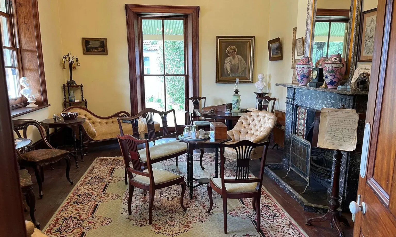
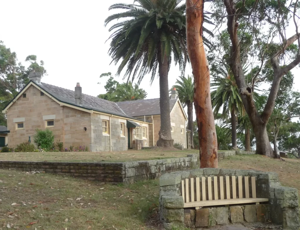
May we now go to the Reserve Carss Bush Park. It is now much improved, the widespread use of stone for paths and walls gives it a special air. It still has the grave kept in a well effective enclosure. It has a stage all of stone and cement which is used to mount outdoor plays and other entertainment, and especially in recent years for the celebration of Australia Day. It has a football field, Olympic pool, tidal pool, barbecue facilities, ambulance station, kiosk etc. but most importantly, it still has Carss Cottage.
It stands on a small promontory facing Kogarah Bay. The promontory has an official name assigned by the Geographical Board, Carss Point (date?) It has had the name Carss on it since 1877 (see Plan 187-2030) and another in 1885 (P192-574R). This latter plan was made by Surveyor Chesterman of a survey of Townsons Bay. William Carss purchased 119 acres in that Point in 1863, by 1865 he and his family were living there. The name has been in continuous use since at least 1885.
In spite of all this on 10 December 1984 the Kogarah Municipal Council resolved to expunge the name Carss from the Point in favour of Centenary Point and resolved to approach the Geographical Names Board regarding concurrence. All hell broke loose. The Geographical Names Board waited one year perhaps to give the question time to sink in. On 10 December 1985 a public notice appeared in the St George & Sutherland Shire Leader inviting submissions of objection. By now hundreds of people had been alerted. The proposal was rejected.
About this time the Kogarah Historical Society resolved after heated debate to nominate Carss Cottage as a subject for a Heritage Order. Some months later, the person delegated to lodge the nomination admitted he did not know where he had lodged it. Individual members were activated by this and another nomination was lodged accompanied by 229 signatures.
The Heritage Council resolved to recommend to the Minister for Environment and Planning that the order be made. The minister agreed and the order was made by NSW Gazette Notice 18 April 1986 (P1708 Col. 2.3).
On 12 June 1986 Kogarah Municipal Council applied under Section 60 of the Heritage Act to perform development in relation to Carss Point. The Section 60 application contained little if any detail and was accompanied by plans bearing the previously rejected name Centenary Point. The Heritage Council were suitably horrified and rejected the application.
Agreement has since been reached regarding the lower level only and work is proceeding.
On 19 May 1988 public notices appeared in the St George & Sutherland Shire Leader stating that a “permanent conservation order is to be made regarding the Carss Cottage, and invites persons to submit comments. Deadline 18 June 1988.”
A permanent conservation order was placed by gazette notice after that date in 1988.
This article was first published in the November 2002 edition of our magazine.
Browse the magazine archive.