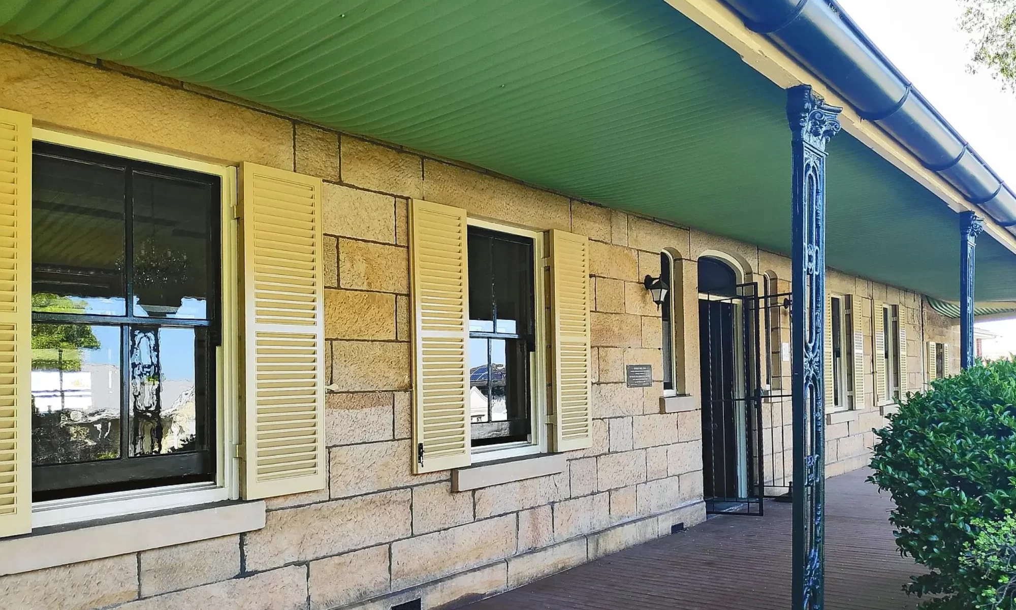
Joseph Davis built “Lydham Hall” on Lydham Hill when he purchased 68 acres of the original land grant given to James Chandler by Governor Brisbane.
This was the first subdivision of Bexley. Large blocks of sandstone were hauled uphill to the building site from the quarry, now the corner of Villiers Street and Arlington Street. All interior woodwork is cedar, originally hand polished, and the marble carrara fireplaces were imported from Italy. James Benson was the stone mason and like most of the early settlers, related to Granny Parkes.
The coach entrance at the junction of Forest Road and Clarence Road, was the scene of one of Bexley’s biggest social nights, when Joseph Davis gave his housewarming.
Carriages swept down the circular driveway to the front entrance (now the rear of the home) and were greeted by an orchestra engaged for the occasion.
The “Lidham Hill” mazurka was especially composed for the opening and the music is still kept at “Lydham Hall”.
Joseph Davis was a butcher and drove his cattle overland from Homebush to the waterhole (now the corner of Herbert and Tyrrell Streets). After resting in the paddocks they were taken to his slaughter yards at the Earl Park site at Arncliffe.
Joseph Davis and his family were unfortunate. His son Frederick born a cripple died at 15 years of age. Joseph became paralysed after lifting a side of beef. He drove around the district in a converted victoria, in a reclining position.
He is buried in the family vault at St. George Church of England, Hurstville, with his wife and son Frederick.
Today footsteps are often heard pacing the floors and treading the stairway. One foot drags as though a cripple is walking. The ghost is affectionately called Joseph by the owners, Mrs. Long is confident Joseph is looking for his money, which was never found after his death. No domestic animal will stay in the house when the ghost walks.
The surrounding streets are named after his sons Frederick, Herbert, Oswell, Stanley (now Tyrrell), Joseph (now Lydham Avenue) and Clarence for his daughter.
A later owner James Stead, was a botanist and named Banksia Station.
He kept a zoo and emus and kangaroos and fine bloodstock was bred on the hilltops. Stead imported stock from his stud farms in New Zealand. The animals were better housed than a lot of humans. Their home had glass windows, cedar shutters and an underlay of bitumen to the iron roof. It still existed until the 1950’s. The old water wells were turned into snake pits. Men today, tell me how as boys, they stoned the snakes, and were chased up trees by the horses.
One dry summer the local housewives were kept on their toes, when two snakes escaped from the snake pit.
The kitchen garden which supplied the home with fresh vegetables was the corner of Lydham Avenue and Herbert Streets (opposite side to Lydham Hall).
Dr. Gordon Craig a former owner, in later years was appalled to see the estate cut up and built on.
The traffic in the early days were mostly timber getters and baker’s carts. They rumbled along in their juggernauts at night, lighting the way with a candle in an inverted bottle.
One man out courting was treed all night by the wild dogs in the Old Forest Road.
Joseph Davis was a founder of Christ Church Bexley and old Bexley School. This caused a bitter comment from the headmistress of Kogarah School, who accused wealthy landowners of trying to boost the sale of their land. Her school being capable of handling the population.
Many attempts have been made to demolish “Lydham Hall”.
It was recently described by a visitor from the ‘National Trust” as a jewel and a treasure hidden for years.
The Royal Australian Historical Society called there on their first official visit to the St. George District and regularly since. Other visitors have been St. George Historical Society, Parramatta Historical Society and Bankstown Historical Society.
“Lydham Hall” is on “Robinson’s Map of Historical Homes and Landmarks”.
It has one of the finest panoramic views of Sydney. Being on one of the highest ridges between Cooks River and Georges River, it has been unspoilt by Sydney’s skyscrapers and home units, as it overshadows them. Recent additions to the view are Gladesville Bridge and new T.C.N. tower. Now Roselands claim to have the highest point but Lydham Hall’s view stretches miles beyond.
A former owner protected the view by placing a covenant on homes built at the rear, when he subdivided. They are not allowed to build more than one storey.
Strange the view should be protected by a blind man. Could he see more than we can today?
This article was first published in the September 1970 edition of our magazine.
Amongst the earliest settlers of the Rockdale area was Mr. James Beehag, a descendant of a French Huguenot farming family formerly known as Behague, who was born at Southminster, a village set amidst the wheatfields on the flat lands of the English country of Essex. This rural village is placed at a meeting of crossroads midway between the tidal River Crouch and the wider sea-estuary known as the Blackwater River, the shore-side shoals of the North Sea being about five miles eastward.
Together with his brother William and sister (later Mrs. E. Way of Messrs. E. Way and Company, formerly drapers in Pitt Street, Sydney, sited in the block between Market and King Streets) he came to Sydney about the year 1836. According to report James Beehag first settled on the site at present occupied by the George Street store of Messrs. David Jones, located at the south-western corner of the intersection of George Street and Barrack Street, almost immediately opposite the General Post Office. About 1838 he moved to what can now be described as north-western Canterbury where, by all accounts, James Beehag was the first to settle in this area. Here he developed a market garden in the vicinity of the Liverpool Road, the property having an area of some thirty acres. The district at that time was a primeval forest which ranged over the low hills and their intervening shallow slopes. It has been mentioned that fresh water was one of the problems against the local settlement and, perhaps the nearest permanent household supply was at the casuarina tree-fringed Cooks River, which flowed a few miles to the south of the Beehag property.
James Beehag, who was of the Presbyterian faith, married Miss Mary Burnett at Scots Church in York Street, Sydney, where the ceremony, held on May 4th, 1840, was conducted by the Reverend William McIntyre. Their first child, named Isaac, was born on July 18th, 1841, and baptised on July 25th of the same year. The family address at this period was simply Liverpool Road and the happy couple were listed as farmers. Other children of the marriage were – Margaret (who married Samuel Tattler), Robert, Gideon (who married Elizabeth Eggleston), Elizabeth (who married William Humphries) and James (who married Elizabeth Humphries).
In 1852 the Canterbury property was sold and the Beehag family moved to the wilds of West Botany where they obtained a triangular shaped block of land some seventy acres in extent. The northern alignment ranged along Bay Street, Rockdale, from its junction, at an apex corner with Rocky Point Road (now Princes Highway) eastwards to the western corner of Pat Moore’s Swamp, located about midway between the present West Botany Street and England Street at Brighton le Sands. The westernmost portion of this plot was largely taken up by a low sandstone hillock, now quarried away for the passage of Bay Street, which once sloped southwards to the later made alignment of Chapel Street. This portion of the property was of little use for farming purposes, consequently when the need arose for a site to erect a Wesleyan Chapel, about 1854, it was offered for sale to the chapel authorities. A small edifice was subsequently erected and provision made for a cemetery. This old-time chapel (and its adjacent Methodist Church of much later construction) still stands in good order, both being situated amidst a wealth of lovely trees, the outstanding feature in the shopping area now known as Rockdale.
According to at least one early map the Beehag grant extended eastwards beyond the swamplands to the western shores of Botany Bay, then an area of sand dunes covered by a dense forest of age-old gum trees and a wealth of picturesque coastal scrub ranging from geebungs to banksias. The new farmland, in its original state, was likewise covered with a forest of huge black-butt and blue-gums, intermixed with angophora trees on the drier slopes. The pellucid fresh water stream, known as Black Creek (or by the less distinctive name of Muddy Creek), flowed through the estate, its banks being lined with feathery-leaved, sombre-hued, casuarina trees. It was hard work to fell the trees of the forest, burn their trunks and branches, remove the stumps, and drain and level, and then plough, the rich fertile land thus exposed for the cultivation of vegetables. No roads went by and a circuitous bush track wound its way northwards, avoiding where possible the marshy tracts bordering the western shore of Black Greek to gain the Cooks River Dam at Tempe. Here a connection was made with the old Cooks River Road which gave access to Sydneytown and its market place.
A small four-roomed cottage of locally burnt bricks was built, a tiny separate kitchen being placed at the rear in accordance with ancient custom. This double-fronted home possessed a shingled roof of silver-grey slats cut from the local she-oaks, and its four rooms had inter-connecting doorways without the benefit of a divisional hallway, In due course a large two-storied weatherboard packing shed was constructed at the eastern side of the little homestead to which lean-to’s were added to house the stables, feed-room, and the two-wheeled dray.
In addition to what may be regarded as his Bay Street estate, James Beehag was fortunate in obtaining another grant of similar land on the lower slopes of Kogarah Hill, east of Rocky Point Road and reaching to the border of Pat Moores Swamp. This land was also suitable for market garden purposes and portion of it, at the eastern end of the present Toomevara Street, is still under cultivation by a family of Chinese people. It is not known at this late date as to whether James Beehag undertook the development of his southern estate of fifty-four acres.
Mary Beehag died about 1853, when the eldest child, Isaac, was twelve years old, and the youngest, James, had attained his second birthday. It was a sad blow to the family to be bereft of their mother, and it is understandable that in due course the husband married Maria Hamilton, A second family eventuated, five in number, which comprised William, Samuel, Arthur, George, and Mary (who married Mr. Spackman).
Social conditions in the West Botany area of somewhat isolated farmlands were very much on the primitive side to say the least in the mid-period of last century. The community were beset by all manner of feuding and petty thieving. For instance, James Beehag’s cow strayed from its pastures into the surrounding bush and was never seen alive after it had been posted as missing. A search party later discovered that the animal had been shot, its carcass dismembered, and its flayed skin burnt in a fire, one of the culprits giving evidence of the theft and the slaughter. Then again the eldest son, Isaac, became the proud owner of a pony, which inadvertently strayed into a neighbouring market garden situated at the north- western corner of the present intersection of West Botany Street and Bay Street. The farmer of this land was not amused at the intrusion and subsequent eating of his precious vegetables and succeeded, in his rage, in slashing the pony’s jaws apart with an axe, an injury which caused the poor animal to be destroyed. These unfortunate happenings, amongst numerous others, did little, to create neighbourly feelings amongst those concerned with their livelihood in the immediate area.
When Isaac was a sturdy lad of eighteen he was engaged in cutting firewood at the Black Forest, later known as Gannon’s Forest and now as Hurstville. This wood, cut to a size suitable for domestic stoves, was taken by horse dray into Sydney and hawked through the back streets for the benefit of the housewives. It was necessary for the lad to sell his load, as the financial return was so essential for the sustenance of the large family at Bay Street, He dare not bring back the load to the farm for this reason.
James Beehag (senior) retired from business as a market gardener in 1883, and went to live in a two-storied house in the Arncliffe section of West Botany Street. Here he largely devoted himself to municipal affairs, being elected an alderman of the first West Botany Council, and in the second and third years of office he filled the position of Mayor. In the fourth year he resigned, but in the fifth year he again occupied the Mayoral chair for another two years, after which he resigned from the Council. At this period he was engaged, with William Hamilton Beehag, the eldest son of his second marriage, in the operation of a market garden located in West Botany Street almost opposite the intersection of Wickham Street, James Beehag (senior) died on September 10th, 1894, and was interred at the Wesleyan portion of the Rookwood Cemetery.
With his demise the estate and garden at the southern side of Bay Street was divided amongst the children of his first marriage, Isaac, Margaret, Elizabeth, and James (junior), all of whom continued to live on their portions of the once so extensive property. However, Robert and Gideon moved to St. Peters and Newtown. Margaret lived at the original cottage, later moving to a more commodious residence erected nearby. Her eldest daughter, Eliza Tattler, eventually married Mr. Edward Draper, a nurseryman, whose family still carry on the business. Strangely enough the original home is more or less intact, together with the large barn, but the second house on the property had been dismantled.
The aforementioned subdivision resulted in the formation of a short dead-end thoroughfare which was named James Street in honour of James Beehag (senior). This street gave access to several of the subdivided properties and was extended, under the title of West Botany Street, southwards to link with President Avenue at Kogarah. The erstwhile rural area is now occupied by all manner of factories and only a portion of the swamp land, together with Draper’s Nursery, remain to give an inkling to the wise of the former activities of that life-long gardener, James Beehag (senior).
For her kind assistance in the preparation of this article, the author is indebted to Mrs. Mary Ann Beaman, a charming lady approaching her ninetieth year, who is a grand-daughter of James Beehag.
This article was first published in the September 1970 edition of our magazine.
During Local Government Week, August 1998, Rockdale City Council launched a series of walk and drive guides to encourage a broad appreciation of the city. They highlight points of interest in the 1991 Rockdale Heritage Study by Meredith Walker and Terry Kass. The Heritage Adviser, Gary Stanley, produced the guides. The council was merged with City of Botany Bay Council in 2016 to form Bayside Council.
These guides are now available in the Resources section of our website:
Arncliffe Heritage Walk – This two-hour walk features many fine Victorian and Federation houses and public buildings.
Bayside Drive – This half hour 10km drive takes in the southern suburbs of Ramsgate Beach, Dolls Point and Sans Souci.
Rockdale Heritage Drive – This 2-hour, 25km drive will give you an understanding of the original landscape, how the City developed, and highlights important natural areas, places and buildings which have been identified as heritage items, or of historic interest.
Rockdale Heritage Walk – These one-hour walks feature many fine Victorian and Federation houses and public buildings.
Wolli Creek Drive – A half hour 10km trip across the Bardwell Valley and down Wolli Creek Valley gives some indication of the land and original vegetation of the City.